Bihar Flood Situation Worsens as Ganges Crosses Danger Mark Across Multiple Districts
Continuous heavy rainfall in catchments and increased discharge from upstream tributaries have pushed the Ganges River above the danger threshold across several districts in Bihar.

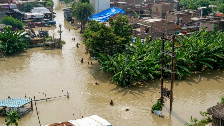
Continuous heavy rainfall in catchments and increased discharge from upstream tributaries have pushed the Ganges River above the danger threshold across several districts in Bihar. Officials from the Water Resources Department confirmed that key monitoring points along the river-including Patna, Buxar, Munger, and Bhagalpur-have recorded water levels exceeding safety marks. Low-lying areas and riparian settlements are experiencing severe inundation, prompting state authorities to issue alerts and deploy emergency response teams.
Rising Ganges Levels Threaten Patna and Surrounding Districts
In Patna, the Ganges has surpassed red-line levels at Digha, Gandhi Ghat, and Hathidah stations. Water has spilled into low-lying agricultural pockets and diara (riverine island) communities. Local authorities report that transportation routes linking suburban villages to district headquarters have been disrupted, forcing residents in submerged zones to rely on country boats for daily travel. Bihar CM Conducts Aerial Survey of Flood-hit Areas, Reviews Rescue and Relief Ops.
Downstream regions including Vaishali, Begusarai, Lakhisarai, and Bhagalpur are witnessing similar water accumulation. Surging tributaries such as the Punpun, Gandak, and Kosi rivers have compounded the volume entering the main Ganges channel, worsening overall flood conditions in central and eastern Bihar.
Impact on Rural Communities and Agriculture
The floodwaters have inundated thousands of hectares of standing crops. Small-scale farmers report damage to seasonal produce, while rural communities face localized shortages of clean drinking water and cattle fodder. Several makeshift mud houses and rural embankments have sustained partial damage due to strong water currents and soil erosion along riverbanks.
Government Response and Emergency Measures
The Disaster Management Department, alongside National Disaster Response Force (NDRF) and State Disaster Response Force (SDRF) personnel, has mobilized teams for rescue and relief ops. Temporary relief shelters and community kitchens have been set up on higher ground to accommodate displaced families. Bihar: Flood Situation Remains Grim in Saran as Ganga, Saryu, Gandak Rivers' Levels Rise.
Engineers from the Water Resources Department are conducting 24/7 surveillance of river embankments to detect and reinforce vulnerable stretches. District Magistrates have been instructed to distribute polythene sheets, dry ration kits, and medical supplies to affected households.
Regional Geography and Seasonal Patterns
Bihar is naturally prone to flood events during the monsoon season due to its topography and dense river network originating in the Himalayas and central Indian plateaus. High rainfall in northern catchment regions routinely increases runoff into the Ganges basin. State authorities maintain that while current water levels require strict vigilance, existing infrastructure and early warning systems are actively functioning to manage flood risks and minimize public distress.
(The above story first appeared on LatestLY on Sep 05, 2026 02:17 PM IST. For more news and updates on politics, world, sports, entertainment and lifestyle, log on to our website latestly.com).