When Will Cyclone Arnab Make Landfall and Which States Will Be Worst Affected?
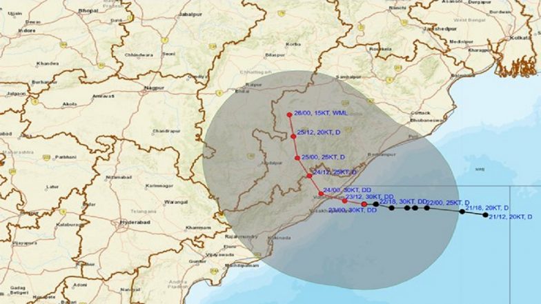
A deep depression over the Bay of Bengal is moving towards the North Andhra Pradesh-South Odisha coast and is expected to cross the coastline between Visakhapatnam and Gopalpur, close to Kalingapatnam, on the night of September 23.

A deep depression over the Bay of Bengal is moving towards the North Andhra Pradesh-South Odisha coast and is expected to cross the coastline between Visakhapatnam and Gopalpur, close to Kalingapatnam, on the night of September 23. According to the latest IMD assessment, the system is expected to cross as a Deep Depression rather than Cyclone Arnab.
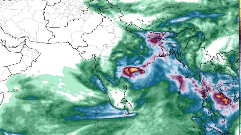
The system is already producing heavy rainfall and strong winds along parts of Odisha and Andhra Pradesh. Authorities have stepped up preparations in vulnerable coastal and adjoining districts, with rainfall, squally winds and rough seas expected to remain the main risks. Cyclone Arnab Update: Deep Depression Nears North Andhra Pradesh-South Odisha Coast; Landfall Expected by Night of September 23.
When Will the Bay of Bengal System Make Landfall?
The IMD's latest forecast puts the likely landfall window on the night of September 23, 2026, with the system expected to cross between Visakhapatnam in Andhra Pradesh and Gopalpur in Odisha, near Kalingapatnam. At 8:30 am on Wednesday, the Deep Depression was located over the westcentral and adjoining northwest Bay of Bengal, around 60 km southeast of Kalingapatnam, according to the latest update cited by India Today. The system was moving westward and was expected to turn west-northwestwards before crossing the coast.
Will It Become Cyclone Arnab Before Landfall?
The answer, according to the latest IMD forecast, is unlikely. The weather system has intensified from a depression into a deep depression, but the IMD expects it to retain that intensity while crossing the coast. Therefore, describing it as Cyclone Arnab would not be accurate at this stage. Arnab is the name next in the North Indian Ocean's cyclone-naming list. It would be assigned only if the system intensifies into a cyclonic storm.
Which States Will Be Worst Affected?
Odisha
Odisha is among the states facing the most significant impact, particularly southern and coastal districts. The IMD has warned of heavy to very heavy rainfall, with isolated extremely heavy rainfall in parts of the state. Southern Odisha districts including Ganjam, Gajapati and Koraput are among the areas under heightened alert. Cyclone Arnab Latest: Deep Depression Over Bay of Bengal To Hit Andhra-Odisha Coast Tonight.
Strong winds are also expected along the Odisha coast. The IMD's coastal bulletin indicated cyclonic winds of around 30-35 knots, gusting up to 45 knots over the South Odisha coast, along with very rough to high sea conditions. Authorities have also moved thousands of people to safer locations in vulnerable areas as rainfall intensified.
Andhra Pradesh
North coastal Andhra Pradesh is directly in the projected path of the system. The IMD has forecast extremely heavy rainfall in Coastal Andhra Pradesh on September 23, followed by very heavy rain on September 24. Strong winds and rough seas are also expected.
Districts including Srikakulam, Vizianagaram, Visakhapatnam, Anakapalle, Alluri Sitharama Raju and Parvathipuram Manyam are among those facing significant weather impacts. Schools were shut in several districts as a precaution. Along the North Andhra coast, winds could reach 25-30 knots, gusting up to 40 knots, according to the IMD coastal bulletin.
Telangana
The system is also expected to bring extremely heavy rainfall to parts of Telangana, although the state is not in the direct landfall zone. The broader weather system is expected to affect inland areas after crossing the coast, with heavy rainfall extending into parts of central and eastern India.
Chhattisgarh and Other States
Chhattisgarh is also under an extreme rainfall threat associated with the system. Heavy to very heavy rainfall is additionally expected in parts of West Bengal, Bihar, Jharkhand and Vidarbha, although these areas are farther from the projected landfall zone.
What Weather Conditions Are Expected?
The immediate concerns along the coast include:
- Heavy to extremely heavy rainfall
- Strong and squally winds
- Very rough to high sea conditions
- Waterlogging and flash-flood risks in vulnerable areas
- Possible disruption to road and other transport services
The IMD has warned that winds along the North Andhra Pradesh-South Odisha coast could reach up to around 75 kmph in gusts during the period around September 23-24.
Why Is It Being Called 'Cyclone Arnab'?
The term has gained traction because Arnab is the next name on the regional cyclone list. However, a weather system does not receive that name merely because it is expected to affect the coast. The current system must first reach the required intensity of a cyclonic storm. As of the latest IMD forecast on September 23, it is expected to cross the coast as a Deep Depression.
Latest Situation
For now, the key weather event is therefore the landfall of a Deep Depression between Visakhapatnam and Gopalpur, rather than an officially formed Cyclone Arnab. Odisha and Andhra Pradesh remain the primary areas of concern, while Telangana, Chhattisgarh and parts of eastern and central India are expected to see significant rainfall as the system moves inland.
(The above story first appeared on LatestLY on Sep 23, 2026 02:09 PM IST. For more news and updates on politics, world, sports, entertainment and lifestyle, log on to our website latestly.com).