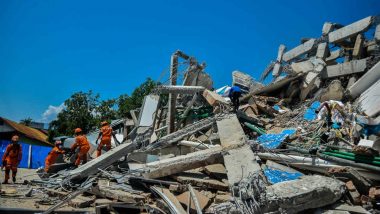
Jakarta, October 2: Satelite pictures show the scale of destruction in city of Palu in Indonesia caused by tsunami, followed by an earthquake on Friday. A 7.5 magnitude quake hit its Sulawesi island triggering a tsunami and killing 1,234 people. Palu was one of the worst-affected cities, with several neighbourhoods almost completely wiped out.
Before and after satellite images, released by DigitalGlobe, show the scale of the devastation in Palu. Coastal residences alongside a Palu shopping mall have vanished from the earth. The tsunami waters destroyed a bridge, flooding nearby homes, show the satelite images. Landslides due to the powerful earthquake have wiped out a village in south Palu.
Indonesia’s National Disaster Mitigation Agency (BNPB) on Tuesday said the death toll from a devastating quake-tsunami on the island of Sulawesi had risen to 1,234 people, up from the previous count of 844. The agency also confirmed that over 500 people have been injured, while 16,372 have been displaced due to the calamity.
The scale of the devastation caused by the Indonesian tsunami and earthquake has been revealed in devastating satellite pictures
📷 via @Reuters pic.twitter.com/AreMlLGYYp
— Elliot Wagland (@elliotwagland) October 2, 2018
So far, 153 victims have been buried in mass graves to prevent an outbreak of disease caused by decomposing bodies. An estimated 2.4 million people were affected by the disaster, said the disaster management agency spokesman Sutopo Purwo Nugroho. He said that 800 were badly injured and more than 61,000 people were displaced.
Prime Minister Narendra Modi has assured the Indonesian President Joko Widodo of all possible help, while three vessels and two aircrafts carrying relief material have been dispatched by the Indian Navy and the Indian Air Force, respectively. (With agency inputs)
(The above story first appeared on LatestLY on Oct 02, 2018 05:32 PM IST. For more news and updates on politics, world, sports, entertainment and lifestyle, log on to our website latestly.com).


 Quickly


