Cyclone Arnab Live Tracker Map on Windy: Bay of Bengal Depression Moves Towards Odisha-Andhra Pradesh Coast
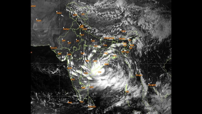
A low-pressure weather system over the Bay of Bengal has intensified as it moves toward India's eastern coastline, with forecasters and disaster management authorities relying on real-time tracking models like the Windy tracker map to monitor the potential development of Cyclone Arnab as it advances toward Andhra Pradesh and Odisha.

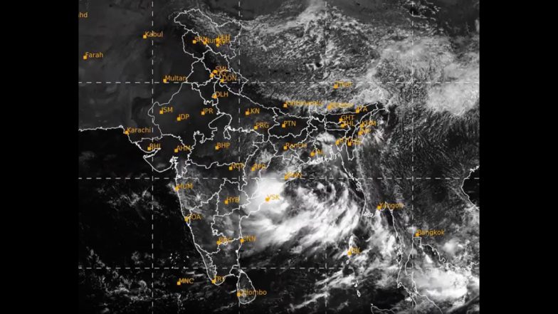
A weather depression developing over the Bay of Bengal has intensified as it moves toward India's eastern coastline, with meteorologists and local authorities relying on real-time platforms like the Windy tracker map to monitor the potential formation of Cyclone Arnab as it advances toward Andhra Pradesh and Odisha over the next 48 hours.
According to updates issued by the India Meteorological Department (IMD), the depression was centered approximately 200 km southeast of Gopalpur in Odisha and 200 km east-southeast of Kalingapatnam in Andhra Pradesh. Moving west-northwestwards at 18 km/h, the IMD projects the weather system to intensify into a deep depression before making landfall between Visakhapatnam and Gopalpur late Wednesday night or early Thursday morning Cyclone Arnab Update: IMD Predicts Landfall Between Visakhapatnam and Gopalpur on September 24.
Cyclone Arnab Live Tracker Map on Windy
Cyclone Arnab Windy Tracker: Where Is the System Now?
According to the IMD, the depression was centred at 8:30 am on September 22 near 17.9°N latitude and 86.0°E longitude. It was located about 200 km southeast of Gopalpur in Odisha, 200 km east-southeast of Kalingapatnam in Andhra Pradesh, 210 km south of Puri and 290 km east of Visakhapatnam.
The system moved westwards at around 18 kmph during the previous six hours and is expected to move west-northwestwards while strengthening further.
IMD Warns of Deep Depression
Satellite animation of #Depression over Westcentral & adjoining Northwest Bay of Bengal pic.twitter.com/OyAVTphcgr
— India Meteorological Department (@Indiametdept) September 22, 2026
Latest satellite imagery of Depression over Westcentral & adjoining Northwest Bay of Bengal pic.twitter.com/PFtg4wGfDx
— India Meteorological Department (@Indiametdept) September 22, 2026
Windy Map Shows System Moving Towards East Coast
Weather-tracking maps such as Windy can be used to visualise the movement of the Bay of Bengal system, including changes in wind, rainfall and pressure around the projected path.
The latest IMD forecast places the likely coastal crossing between Visakhapatnam and Gopalpur. The system is currently expected to reach the coast as a deep depression, rather than a confirmed cyclonic storm. The IMD's forecast will remain the primary reference for the system's official intensity, track and warnings as conditions evolve.
Will It Be Called Cyclone Arnab?
The term “Cyclone Arnab” is being used in some reports because Arnab is the next name in the North Indian Ocean cyclone naming list. However, the IMD has not yet confirmed the formation of a cyclonic storm. The current official classification is a depression, with strengthening into a deep depression expected.
If the system reaches the required intensity for classification as a cyclonic storm, the name Arnab would be used. The name was contributed by Bangladesh and means “ocean” in Bengali.
IMD Forecasts Heavy Rain in Odisha
The weather system is already affecting rainfall over parts of Odisha. The IMD has forecast very heavy rainfall on September 22, followed by extremely heavy rainfall on September 23 and 24 in the state. Very heavy rainfall is also expected on September 25, with heavy rain possible on September 26.
The IMD has warned that intense rainfall could lead to waterlogging, flooding in low-lying areas and rising water levels in rivers, particularly in areas that have already received significant rain.
Andhra Pradesh Also Under Watch
The north Andhra Pradesh coast is also being monitored as the system moves closer. The IMD expects the depression to continue moving west-northwestwards before crossing the north Andhra Pradesh–south Odisha coast between Visakhapatnam and Gopalpur.
The weather department has also warned of squally conditions and rough to very rough seas in parts of the Bay of Bengal as the system approaches the coast.
Odisha Takes Precautionary Measures
Several districts in Odisha have announced precautionary measures because of the rainfall forecast. Schools and Anganwadi centres in districts including Khurda, Ganjam, Jagatsinghpur and Gajapati have been ordered to remain closed for specified periods amid the weather warning. Authorities are also preparing for possible flooding and other rain-related disruptions as the system approaches the coast.
What to Watch on the Windy Tracker
The key factors to monitor over the next 24 to 48 hours are the system's movement, wind intensity, rainfall distribution and official classification. For now, the IMD forecast indicates that the depression will strengthen into a deep depression and cross the Odisha-Andhra Pradesh coast between September 23 and early September 24.
Any change in intensity or track will be reflected in subsequent IMD bulletins. Until then, references to “Cyclone Arnab” should be understood as a possible future name rather than confirmation that a cyclone has already formed.
(The above story first appeared on LatestLY on Sep 22, 2026 05:02 PM IST. For more news and updates on politics, world, sports, entertainment and lifestyle, log on to our website latestly.com).