
Cyclone Arnab Update: IMD Predicts Landfall Between Visakhapatnam and Gopalpur on September 24
A weather depression over the Bay of Bengal has intensified as it moves toward the eastern coast of India, with the India Meteorological Department (IMD) warning it is likely to turn into a deep depression before making landfall between Andhra Pradesh and Odisha over the next 48 hours.

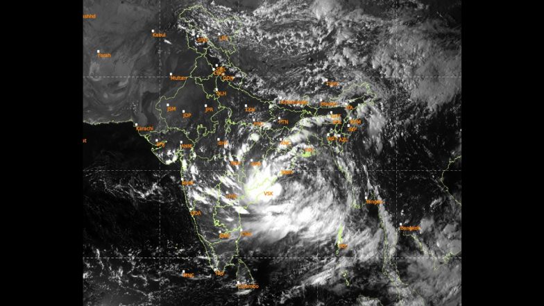
A depression over the west-central and adjoining northwest Bay of Bengal is expected to intensify into a deep depression over the next 12 hours, with the system forecast to move towards the north Andhra Pradesh–south Odisha coast, the India Meteorological Department (IMD) said on Tuesday. The system is likely to cross between Visakhapatnam and Gopalpur during the night of September 23 and the early hours of September 24.
Despite speculation over the possible formation of Cyclone Arnab, the IMD has so far forecast the system to cross the coast as a deep depression, rather than confirming cyclone formation. The name Arnab would be used if the system develops into a cyclone. Cyclone Shakhti Update: Severe Cyclonic Storm Shakhti To Weaken Into Cyclonic Storm by October 6 Morning, Says IMD; Check Details.
IMD Warns of Deep Depression
Satellite animation of #Depression over Westcentral & adjoining Northwest Bay of Bengal pic.twitter.com/OyAVTphcgr
— India Meteorological Department (@Indiametdept) September 22, 2026
Latest satellite imagery of Depression over Westcentral & adjoining Northwest Bay of Bengal pic.twitter.com/PFtg4wGfDx
— India Meteorological Department (@Indiametdept) September 22, 2026
Depression Moves Towards Odisha-Andhra Coast
According to the latest IMD update, the depression was centred at around 8:30 am on September 22 near latitude 17.9°N and longitude 86.0°E. It was approximately 200 km southeast of Gopalpur in Odisha and 290 km east of Visakhapatnam in Andhra Pradesh.
The weather system is expected to move west-northwestwards and strengthen into a deep depression during the next 12 hours. It is then forecast to continue moving in the same direction before crossing the coast between Visakhapatnam and Gopalpur. Cyclone Shakhti Live Tracker Map on Windy: Cyclone Shakti Moves West-Southwest, IMD Issues Warning for Maharashtra; Check Real-Time Status Here.
No Cyclone Arnab Confirmation Yet
The developing system has been referred to as a possible Cyclone Arnab because Arnab is the next name on the regional list of cyclone names. The name was contributed by Bangladesh and means “ocean” in Bengali.
However, the IMD has not confirmed that the system will become a cyclonic storm. Current forecasts indicate that it is expected to make landfall as a deep depression.
Heavy Rainfall Warning in Odisha
The weather system has already triggered heavy rainfall in several parts of Odisha. Authorities have warned of the possibility of very heavy to extremely heavy rainfall in southern and coastal districts.
The IMD has issued a red alert for several areas, including parts of Koraput, Gajapati and Ganjam for September 23-24. Kalahandi, Nabarangpur, Koraput and Malkangiri are also under red alert for September 24-25.
The weather department has warned that intense rainfall could result in waterlogging, urban flooding, rising river levels and landslides, particularly in areas that have already experienced sustained rainfall.
Schools Shut in Several Odisha Districts
Authorities have announced the closure of schools and Anganwadi centres in several districts as a precautionary measure.
Schools in Khurda, Ganjam, Jagatsinghpur and Gajapati have been ordered shut for varying periods. Malkangiri has also announced school closures until September 24. Government employees in some affected districts have been asked to remain available as administrations prepare for possible emergencies.
The Odisha government has also restricted movement on some roads and suspended ferry services between Satapada and Jahnikuda in Chilika Lake until September 25 because of the weather conditions.
Andhra Pradesh Also On Alert
Coastal Andhra Pradesh is expected to experience heavy to extremely heavy rainfall as the system approaches. The IMD has forecast extremely heavy rainfall for September 23 and 24, along with strong winds.
Along the north Andhra coast, squally weather is expected, with winds potentially reaching higher speeds during thunderstorms and heavy rain. Coastal conditions are forecast to become rough to very rough in affected areas.
Landfall Expected Between September 23-24
The IMD's current forecast puts the likely coastal crossing between Visakhapatnam and Gopalpur during the night of September 23 and early hours of September 24.
Officials in Odisha have activated preparedness measures, including keeping cyclone and flood shelters ready in vulnerable areas. The focus remains on managing heavy rainfall, flooding and strong winds as the system approaches the coast.
For now, the weather system remains classified as a depression, with the IMD closely monitoring its movement and intensity. Further updates will determine whether it strengthens beyond the deep-depression stage before reaching the coast.
(The above story first appeared on LatestLY on Sep 22, 2026 04:34 PM IST. For more news and updates on politics, world, sports, entertainment and lifestyle, log on to our website latestly.com).