What Does ISRO INSAT-3DS Satellite’s Dramatic Cloud Divide Mean?
India's weather has taken a striking turn, with a fresh ISRO INSAT-3DS satellite image showing a dramatic contrast in cloud cover across the country. While thick clouds blanket large parts of eastern, northeastern and southern India, western and northwestern regions appear relatively clear.

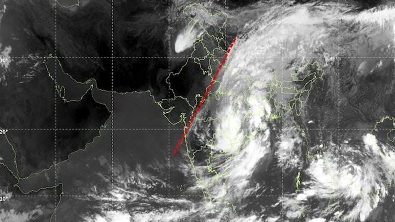
India's weather has taken a striking turn, with a fresh ISRO INSAT-3DS satellite image showing a dramatic contrast in cloud cover across the country. While thick clouds blanket large parts of eastern, northeastern and southern India, western and northwestern regions appear relatively clear.
The image, captured on September 25, 2026, using the satellite's thermal infrared channel at a wavelength of 10.83 micrometres, provides a detailed view of cloud formations over India and neighbouring regions.
What Does The INSAT-3DS Image Show?
The most prominent feature is a broad and bright cloud mass extending from the Bay of Bengal across eastern and northeastern India. Additional cloud bands can be seen over the southern peninsula and adjoining oceanic regions.
In contrast, large parts of western and northwestern India appear comparatively cloud-free, creating a sharp visual divide between the two regions. 'Cyclone Arnab' Myth Busted: Know Why the Bay of Bengal Weather System Is Actually a Deep Depression.
ISRO INSAT-3DS Satellite Shows Dramatic Cloud Divide, East and South Under Thick Cover
ISRO’s satellite image of India today looks almost unreal. 😳
One side is covered in dense clouds, while the other is remarkably clear -- almost as if someone drew a line across the country.
No filter.
No Photoshop.
Just INSAT-3DS showing India’s weather from space.… pic.twitter.com/uXvo74HTWy
— Asif Iqbal (@AsifInsights) September 25, 2026
The bright cloud formations in the thermal infrared image indicate colder cloud tops. Such formations can be associated with deeper clouds and atmospheric convection, although the satellite image alone cannot determine the exact weather system responsible.
Why Is There A Sharp Cloud Divide?
The satellite captured these conditions as the southwest monsoon enters its withdrawal phase over parts of India. However, several atmospheric systems can continue to influence rainfall even as the monsoon begins retreating.
Cloud formations over eastern India and the Bay of Bengal can be linked to moisture-laden winds, low-pressure areas and other atmospheric disturbances. The precise cause of the cloud pattern requires analysis of additional meteorological observations and weather models. Cyclone Arnab Live Tracker Map on Windy: Deep Depression Nears Odisha-Andhra Coast, Landfall Tonight.
How INSAT-3DS Helps Track Weather
The INSAT-3DS is part of India's meteorological satellite programme and provides observations of clouds, atmospheric temperature, humidity and other weather parameters.
Its thermal infrared instruments detect radiation emitted by Earth and the atmosphere, allowing meteorologists to monitor cloud patterns even during nighttime.
The satellite's observations are used by the India Meteorological Department (IMD) for weather forecasting, monitoring severe weather and tracking atmospheric systems.
The latest INSAT-3DS image highlights how dramatically cloud cover can vary across India at the same time, with eastern and southern regions experiencing much more extensive cloud activity while western and northwestern areas remain comparatively clear.
(The above story first appeared on LatestLY on Sep 26, 2026 05:34 PM IST. For more news and updates on politics, world, sports, entertainment and lifestyle, log on to our website latestly.com).