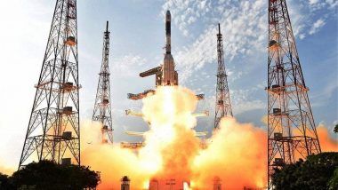
Sriharikota, January 12: The Indian Space Research Organisation (ISRO) on Friday successfully launched the 100th satellite ‘Cartosat-2’ series from Satish Dhawan Space Centre at Sriharikota. ‘Cartosat-2’ series, the weather observation series satellite has been successfully launched along with 30 other satellites at 9.28 am on Friday. On its 42nd mission, the ISRO trusted its workhorse ‘PSLV-C40’ to carry the weather observation ‘Cartosat-2’ series satellite and 30 co-passengers (together weighing about 613 kg) at lift-off today. The 44.4-metre-tall rocket lifted off from the first launch pad of Sriharikota today morning.
As per reports, the 30 co-passenger satellites comprise one micro and nanosatellite each from India as well as three micro and 25 nanosatellites from six countries including Canada, Finland, France, Korea, the United Kingdom and United States of America. The total weight of all the 31 satellites carried on-board PSLV-C40 is about 1,323kg. The 28 international customer satellites are being launched as part of the commercial arrangements between ISRO and its commercial arm ‘Antrix Corporation Ltd’, PTI reported.
Satellite ‘Cartosat-2’ series launch: All nano satellites separated pic.twitter.com/DEq9CUPZF6
— ANI (@ANI) January 12, 2018
During the last PSLV launch we had problems, today what has happened proves that the problem was properly addressed and rectified. Happy to give this new year gift to the country: AS Kiran, ISRO pic.twitter.com/qoyMh95cNP
— ANI (@ANI) January 12, 2018
The payload fairing has successfully separated from satellite ‘Cartosat-2’ series, making it India’s 100th satellite that has been sent up the rocket. It has to be noted that the 30 satellites include two satellites from India and 28 satellites from six other countries. As per scientists, the mission is a unique one as the satellites will be launched in two orbits.
As per reports, the Polar Satellite Launch Vehicle or PSLV lifted off at 9.29 am from Sriharikota in Andhra Pradesh and a key component that had failed in August. This is the 42nd flight of the PSLV. The successful launch comes after four months after failed launches. Reports further state that lift-off was postponed by a minute because of fear of collision with space debris.
To recall, the Indian Space agency had successfully launched Cartosat-2 Series satellite on 22 June 2016. It is similar to the earlier Cartosat-2, 2A and 2B. As per reports, the images sent by Cartosat-2 series satellite will be useful for cartographic applications, urban and rural applications, coastal land use and regulation, road network monitoring, water distribution, creation of land use maps and change detection to bring out geographical Land Information Systems and Geographical Information System applications.
(The above story first appeared on LatestLY on Jan 12, 2018 10:39 AM IST. For more news and updates on politics, world, sports, entertainment and lifestyle, log on to our website latestly.com).


 Quickly


