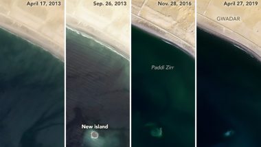
A mud island named Zalzala Koh (meaning Earthquake Island in Urdu) has vanished in the waters of the Arabian sea. The mud island had emerged after a 7.8 magnitude earthquake struck in the Baluchistan in October 2013. And within barely 6 years the existence of this island has vanished off the Pakistan coast. NASA released a series of images recently which trace the disappearance of this island into the ocean waters. Indonesia's Merapi Volcano Unleashes River of Lava.
The earthquake of 2013 caused major destruction on land, killing over 800 people. But once the tremors subsided, there was a new formation in the bay waters of the city of Gwadar. The volcanic forces were in action and a mud volcano had pushed the soil up from the seabed, forming this mud island. Bill Barnhart, a geologist at the U.S. Geological Survey told NASA Earth Observatory at the time, "The island is really just a big pile of mud from the seafloor that got pushed up [by the seismic activity]." NASA in its recent images showed that the Zalzala Koh is submerged under the waves. Italy’s Stromboli Volcano Eruption Caught on Camera, Watch Terrifying Viral Footage of the Explosion.
Check NASA's Pics of The Disappearing Mud Island in Pakistan:
In 2013, when an earthquake triggered a nearby mud volcano, a tiny island named Zalzala Koh (Urdu for "Earthquake Mountain") emerged off the coast of Pakistan. Over six years, @NASAEarth satellites have observed its disappearance back into the sea. More: https://t.co/4fPFZ8uIeb pic.twitter.com/LbX4iuwQ6f
— NASA (@NASA) July 29, 2019
The island was about 90 meters wide, and 40 meters long when first found. Scientists had predicted during its formation itself that it would not last for a long time. The tides and waves have eroded the muddy formation. While the surface of this island was lifeless, it was a good haven for coral life along with other marine animals. It had also boosted the local fishing industry for a while. The Zalzala Koh is an example of short-lived earth transformations.
(The above story first appeared on LatestLY on Jul 30, 2019 09:09 AM IST. For more news and updates on politics, world, sports, entertainment and lifestyle, log on to our website latestly.com).


 Quickly


