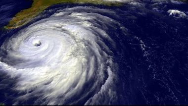
New Delhi, October 1: Cyclonic storm Shaheen has been formed in the Arabian Sea and is set to further intensify into a Severe Cyclonic Storm during the next 24 hours. The system is expected to move west-northwestwards during the next 36 hours. It is likely to re-curve west-southwestwards skirting Makran coast and would move towards the Gulf of Oman and weaken gradually. According to details by the India Meteorological Department (IMD), the system is now moving away from the Indian coast bringing heavy rainfall to coastal Gujarat and Maharashtra. Cyclone Shaheen Live Tracker Map on Windy: Cyclonic Storm Forms in Arabian Sea, Likely To Move Towards Pakistan-Makran Coasts; Check Realtime Status Here.
According to the IMD forecast, the 'deep depression' over the northeast Arabian Sea off Gujarat coast moved west-northwestwards and intensified into Cyclonic storm 'Shaheen' today and lies about 400 km west-northwest of Devbhoomi Dwarka (Gujarat), 260 km south-southwest of Karachi (Pakistan) and 530 km east-southeast of Chabahar Port (Iran). Cyclone Shaheen Forms in Arabian Sea After Cyclone Gulab Weakens; Here's What 'Shaheen', the Name Given by Qatar, Means.
The IMD said that rainfall activity is likely to increase over south Peninsular India from October 1 with heavy rainfall over Tamil Nadu, Kerala, Coastal and South Interior Karnataka during October 1-4. The weather agency said that isolated very heavy falls were also likely over Tamil Nadu during October 2-4.
(The above story first appeared on LatestLY on Oct 01, 2021 12:02 PM IST. For more news and updates on politics, world, sports, entertainment and lifestyle, log on to our website latestly.com).


 Quickly


